

- Property Type: Trust-Owned
- Date Added: 2019
- Marblemount
- 67 acres
- Open to the Public, Featured Property
- Fishing
- Hiking & Walking
Conservation Story
Marblemount Conservation Area is located along the north bank of the Skagit River, west of Marblemount near Corkindale Creek, and features a 67-acre riparian forest. The land was primarily protected for its diverse aquatic and forest habitat supporting salmon and other wildlife species.
Marblemount Conservation Area features a loop hiking trail, including interpretive signs, like the one seen here. Coast Salish Tribes use the 13 moons lunar calendar to demonstrate the connections between plants and animals in our environment in relation to the change of the seasons. River access through the this Conservation Area allows for fishing access and salmon viewing during spawning season.
A portion of the conservation area was purchased in 2019 with a grant from the Washington State Salmon Recovery Funding Board. The remaining portion was donated in 2020.

Site History and Ecology
Marblemount Conservation Area includes 3,000 feet of riverine shoreline in the Upper Skagit River Watershed, where the river historically migrated across the glacial valley. At this location, the river is home to all 5 species of Pacific salmon and 3 species of trout: chinook, sockeye, coho, pink, chum, steelhead, cutthroat trout, bull trout, and rainbow trout.
The property and adjacent lands also provide habitat for the endangered gray wolf and northern spotted owl. Bald eagles, beavers, coyotes, deer, cavity nesting birds, waterfowl, and many locally common amphibians are all known to utilize the property.
The property helps sustain critical ecological processes by providing space for flooding and river migration, supplying coarse woody debris, and aiding in nutrient production. This portion of the Skagit River is a designated Wild & Scenic River, granting it a right to exist for the enjoyment of present and future generations.

How to Get There
Marblemount Conservation Area is located 3 miles west of the town of Marblemount on Highway 20. Look for the private road labeled Ponder Roses on the Skagit River side of the road. Visitors can park at the gravel area just before the gate. Walk down the driveway behind the gate, and take the first left. Pass a tall metal shed on your right and continue on until you see the trail split. This is the beginning of the loop trail; either direction will take you to the river.
Access
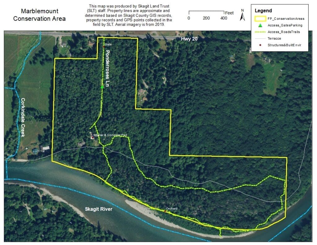
Please visit this property! It is open for public access, which has been developed via a 1.25-mile-long loop trail and a partially covered gathering area. There is a small parking lot located at the gate that can accommodate 2-3 cars. Find more information about this trail on Washington Trails Association’s website.


You might also like

Community Hikes at Yudwasta Big Rock Park
Despite light rain in the forecast, over 30 community members — many of whom had never been up to Big…
Read MoreCommunity Hikes at Yudwasta Big Rock Park
Skagit Land Trust Helps Protect More Critical Skagit River Salmon Habitat
If you look at a map of the Skagit River east of Sedro-Woolley, you’ll see a large river wind its…
Read MoreSkagit Land Trust Helps Protect More Critical Skagit River Salmon Habitat
A Place for Wild Things – Expanding a Corridor of Conservation
This spring, Skagit Land Trust was gifted a 56-acre mosaic of forest, wetland, and open meadow near Sedro-Woolley. The land…
Read MoreA Place for Wild Things – Expanding a Corridor of Conservation